EBGBS
  • Home
  • Latest News
    • Draft Local Plan
    • Neighbourhood Plan
    • Aldenham Reservoir
    • Woodcock Hill Village Green
    • Sky Studios
    • Elstree Aerodrome
    • Organ Hall
    • Hartfield Avenue
    • Barnet Lane
    • Solar Plant
    • Tykeswater Lane
    • Retirement Properties, Elstree
    • Allum Lane Fields
    • Old School House
    • 16 Allum Lane
  • Newsletters
  • Public Rights of Way
  • Keeping It Green
  • Who's Who?
  • Join/Contact Us
  • Rules
Home Page

What is the Green Belt

Current Plans

Newsletters and Diary

About Us

Join Us

Contact Details

Associated Organisations
​
Keeping It Green


Members Page

​
MENU 


Picture
Picture
What is the Green Belt?
 
The fundamental aim of Green Belt policy is to prevent urban sprawl by keeping land permanently open; the essential characteristics of Green Belts are their openness and their permanence.
 
Green Belt serves 5 purposes:
(a) to check the unrestricted sprawl of large built-up areas;
 
(b) to prevent neighbouring towns merging into one another;
 
(c) to assist in safeguarding the countryside from encroachment;
 
(d) to preserve the setting and special character of historic towns; and
 
(e) to assist in urban regeneration, by encouraging the recycling of derelict and other urban land.
 
 Additional benefits of Green Belt:
(a)  Recreation, sport, health - Green Belt protection ensures we enjoy open land and countryside. Our Green Belt includes a country park, playing fields, they support sport and recreation and health – including reducing stress by providing peaceful, breathing spaces and public rights of way
 
(b)  Eco-system benefits - Different types of open land provide multiple eco-system benefits which include urban cooling, improved air quality, flood protection and carbon absorption (especially woodland areas).
 
(c)  Future proofing - As Elstree and Borehamwood has grown so drastically in recent years, so more people come to rely on protected green spaces for the many benefits they provide. Protected Green Belt lands should be enhanced to provide more benefits in future.
 
 
For further information see:       (Use the BACK button to return to ebgreenbelt.org)
 
https://www.gov.uk/guidance/national-planning-policy-framework/13-protecting-green-belt-land
 
https://researchbriefings.parliament.uk/ResearchBriefing/Summary/SN00934


Wikipedia on the the Green Belt
Green belt (United Kingdom)
From Wikipedia, the free encyclopedia
  (Redirected from Green Belt (UK))
 
 
In British town planning, the Green Belt is a policy for controlling urban growth.
​
The idea is for a ring of countryside where urbanisation will be resisted for the foreseeable future, maintaining an area where agriculture, forestry and outdoor leisure can be expected to prevail. The fundamental aim of green belt policy is to prevent urban sprawl by keeping land permanently open, and consequently the most important attribute of green belts is their openness.
The Metropolitan Green Belt around London was first proposed by the Greater London Regional Planning Committee in 1935. The Town and Country Planning Act 1947 then allowed local authorities to include green belt proposals in their development plans. In 1955, Minister of Housing Duncan Sandys encouraged local authorities around the country to consider protecting land around their towns and cities by the formal designation of clearly defined green belts.
Green belt policy has been criticised for reducing the amount of land available for building and therefore pushing up house prices, as 70% of the cost of building new houses is the purchase of the land (up from 25% in the late 1950s). 
​

Picture
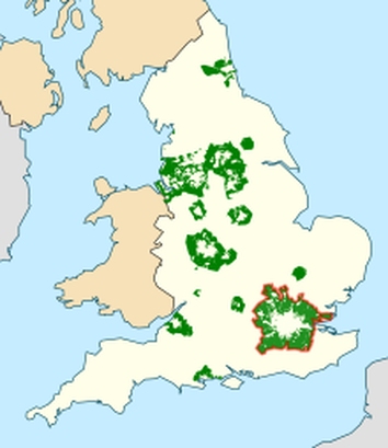
Designated areas of green belt in England; the Metropolitan Green Belt outlined in red.

History

The term emerged from continental Europe where broad boulevards were increasingly used to separate new development from the centre of historic towns; most notably the Ringstraße in Vienna. Various proposals were put forward from 1890 onwards but the first to garner widespread support was put forward by the London Society in its "Development Plan of Greater London" 1919.
Alongside the CPRE they lobbied for a continuous belt (of up to two miles wide) to prevent urban sprawl, beyond which new development could occur.
Implementation of the notion dated from Herbert Morrison's 1934 leadership of the London County Council. It was first formally proposed by the Greater London Regional Planning Committee in 1935, "to provide a reserve supply of public open spaces and of recreational areas and to establish a green belt or girdle of open space". It was again included in an advisory Greater London Plan prepared by Patrick Abercrombie in 1944 (which sought a belt of up to six miles wide).
However, it was some 14 years before the elected local authorities responsible for the area around London had all defined the area on scaled maps with some precision (encouraged by Duncan Sandys to designate a belt of some 7–10 miles wide).
New provisions for compensation in the 1947 Town and Country Planning Act allowed local authorities around the country to incorporate green belt proposals in their first development plans. The codification of Green Belt policy and its extension to areas other than London came with the historic Circular 42/55 inviting local planning authorities to consider the establishment of Green Belts. This decision was made in tandem with the 1946 New Towns Act, which sought to depopulate urban centres in the South East of England and accommodate people in new settlements elsewhere. Green belt could therefore be designated by local authorities without worry that it would come into conflict with pressure from population growth.
​
As the outward growth of London was seen to be firmly repressed, residents owning properties further from the built-up area also campaigned for this policy of urban restraint, partly to safeguard their own investments but often invoking an idealised scenic/rustic argument which laid the blame for most social ills upon urban influences. In mid-1971, for example, the government decided to extend the Metropolitan Green Belt northwards to include almost all of Hertfordshire. The Metropolitan Green Belt now covers parts of 68 different Districts or Boroughs.
Since 1955 London's green belt has extended significantly, stretching some 35 miles out in places. London's green belt now covers an area of 516,000 hectares, an area broadly three times larger than that of London itself. The London Society began debate about the city's green belt in 2014 with publication of a report entitled "Green Sprawl".[19][20][21] Other organisations, including the Planning Officers Society,[22] have since responded with specific calls for a review and proposals to balance land release with environmental protection.In 2016, the London Society and All Party Parliamentary Group (APPG) for London's Planning and Built Environment published plans for a 'green web' to replace the green belt in some locations.[26] The ambition is to create a "multifunctional green infrastructure landscape" in which new-build and publicly accessible natural space sat side by side.[27]
Research undertaken by the London School of Economics in 2016 suggests that by 1979, the area covered by Greenbelt in England comprised 721,500 hectares, and by 1993, this had been extended to 1,652,310 hectares.
​

Proudly powered by Weebly
  • Home
  • Latest News
    • Draft Local Plan
    • Neighbourhood Plan
    • Aldenham Reservoir
    • Woodcock Hill Village Green
    • Sky Studios
    • Elstree Aerodrome
    • Organ Hall
    • Hartfield Avenue
    • Barnet Lane
    • Solar Plant
    • Tykeswater Lane
    • Retirement Properties, Elstree
    • Allum Lane Fields
    • Old School House
    • 16 Allum Lane
  • Newsletters
  • Public Rights of Way
  • Keeping It Green
  • Who's Who?
  • Join/Contact Us
  • Rules